Geohazard Management
The Land Conservation Field provides various technical services to protect society from various disasters such as large-scale earthquakes, volcanic eruptions, and torrential rains, in order to realize land conservation and people's safety and security in Japan and abroad.
Especially in recent years, with the recent spate of localized extreme downpours and large-scale earthquakes, we have been at the forefront of emergency measures against these disasters, as well as permanent measures with regional development in mind.
Engineering Services
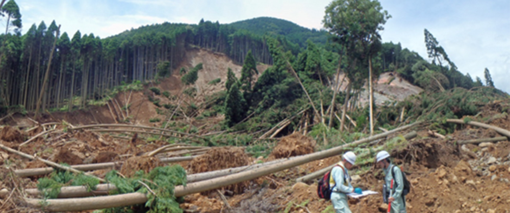
In order to prevent slope disasters from occurring, it is important to continuously observe the slope changes using measurement equipment and to monitor these changes on a regular basis.
There are three types of methods for measuring slope hazards: manual observation, semi-automatic observation, and automatic observation. Manual and semi-automatic observations require observers to visit the site to acquire data and organize the data after acquisition to understand slope changes. On the other hand, automatic observation is a system in which data acquisition, data transfer, and graphing are all done on a computer, and slope changes can be monitored in real time even in remote areas via a telephone line or radio.
We have developed the "Landslide Automatic Watching and Surveillance System (LAWS)". This system has been used for a wide range of slope disasters, including landslides, and more than 200 systems have been installed throughout Japan. In recent years, LAWS has also been used to view observation data via the Internet (iLAWS) and send out warning e-mails, and has been very effective in reducing landslide disasters and ensuring safe construction of countermeasure works.
In recent years, global warming has become an issue, and the importance of forests and greenery has been reaffirmed. We are engaged in projects to prevent and mitigate mountain disasters, secure water source irrigation, and preserve the forest environment through mountain control projects. Landslides, one type of mountain disaster in particular, are large in scale and can cause massive sediment transport. We are engaged in projects to protect mountain greenery from landslide disasters with the technology and experience we have cultivated over the years.
In mountainous areas, forest roads are used not only for mountain control projects but also as a way of life for people. Through our forest road projects, we contribute to projects that support the lives of local communities.
Preventing roads, which are the foundation of social infrastructure, from landslides and securing the transportation network are extremely important for protecting the social and industrial activities of the people and human lives. As a means of preventing disasters, road disaster prevention inspections play an extremely important role.
Road disaster prevention inspections are detailed inspections of the safety of road slopes and road facilities (embankments, retaining walls, etc.) in order to prevent disasters caused by extreme weather events (heavy rain, earthquakes, heavy snowfall) that have been occurring frequently in recent years. Since the inspection covers a wide range of areas such as rockfall, collapse, landslide, mudslide, embankment, retaining wall, avalanche, etc., our experienced and highly qualified engineers will inspect to investigate and take countermeasures for landslide movement phenomena. The results of landslide inspections are compiled into a database through the Disaster Prevention Medical Record to promote efficient management.
For hazardous areas identified through disaster prevention inspections, etc., we will conduct accurate investigations and optimize/design roads to make them safe, secure, and resistant to disasters. When a disaster occurs, we will promptly respond with surveys and designs from emergency response to restoration. For sections with advance traffic control, we will also conduct studies aimed at relaxing or lifting rainfall control standards.
Because the slopes around the reservoir will be newly submerged or affected by water level fluctuations due to the construction and operation of the dam, landslide activity distributed within the slopes may become more active, and loose bedrock, cliff-pit deposits, etc., which were stable under normal weather conditions, may start to move anew. In order to prevent such slope fluctuations from significantly affecting the safety of dams and surrounding facilities, it is necessary to conduct surveys and studies that take into account the unique conditions of reservoir slopes, in addition to sufficient studies prior to water flooding. We have extensive experience in studying various dams throughout Japan, and provide consulting services ranging from investigation, analysis, prediction, planning of countermeasures, and design to direct damage to structures caused by landslides, slope failures, and falling rocks that occur on reservoir slopes, to indirect damage assumed to be caused by stepped waves. We provide consulting services ranging from investigation, analysis, prediction, and planning of countermeasures to design.
In recent years, landslides, slope failures, and other landslide disasters have been occurring more frequently due to abnormal weather conditions associated with global warming, and there is a need to develop a safe and secure environment in the river and erosion control field.
To address these issues, we are working on the investigation and design of slope problems in the river and erosion control fields from both software and hardware perspectives, making full use of the slope stabilization technologies we have cultivated in many fields.
- Survey and design of landslide prevention areas, steep slope prevention areas, and hillside waste areas
- When considering slope countermeasures for landslides and collapses, it is important to accurately grasp the scale of the phenomenon and its causes. For this reason, we plan and conduct rational surveys and observations, and design highly reliable countermeasure facilities.
- Hazardous Area Establishment Survey (Basic Survey) in accordance with the Landslide Disaster Prevention Act
- As part of the soft measures, basic surveys associated with the Landslide Prevention Law will be conducted with due consideration for residents, along with clarifying the appropriateness of the set-aside area.
The topography, geology, and weather conditions of Japan's land are extremely severe, and protecting the lives and property of the people from natural disasters is the most fundamental issue. About 70% of the country is mountainous and hilly, with active earthquakes and volcanic activity, and prone to typhoons and torrential rains. When damage to roads, rivers, etc. occurs due to natural disasters such as slope failures, landslides, and rock falls, our nationwide team of expert engineers quickly conducts on-site inspections, and with our wealth of experience and expertise in slope disaster recovery, we quickly respond with a series of measures ranging from emergency recovery to survey, instrument observation, analysis, and design of countermeasures for permanent countermeasures. We also provide disaster restoration and re-disaster prevention services. We also provide technical support for disaster recovery and disaster prevention.
We provide landslide risk management services for private businesses by utilizing our know-how cultivated in public works projects. In recent years, landslide disasters caused by large-scale earthquakes and torrential rains have become more frequent and the risk of disasters has increased. Through our landslide risk management services, we contribute to the enhancement of corporate and asset values of business operators.
Preliminary and detailed design using 3D models with BIM/CIM is being conducted to enhance the sophistication, efficiency, and productivity of studies and detailed design of slope countermeasure works.
We are working on 3D automatic design of landslide countermeasure works such as piles, anchors, shotcrete slopes, water wells, lateral boring, head earth removal, and push fill, through programming, and are performing detailed design of countermeasure works with a 3D view, which is difficult with 2D. The 3D model created can be used to automatically calculate construction quantities and estimated construction costs in a batch.
To characterize the target watershed, we investigate topography, geological elements, past sediment transport history, conditions of collapsed areas, exposed rock locations in the stream, and sediment and macro-gravel deposition. We also develop erosion control plans that effectively and efficiently deal with the harmful production and runoff of sediment that causes landslides. We will assume the extent of damage based on numerical analysis such as inundation analysis, propose the optimal layout of erosion control facilities, and study the damage mitigation effects associated with the installation of erosion control facilities. We will also conduct a cost-benefit analysis and prepare explanatory materials for the local community and project evaluation committees.
We will conduct a detailed field survey to identify suitable sites for erosion control weirs, compare proposed facility layouts (combination of form, structure, installation locations, etc.), and conduct preliminary and detailed design of erosion control weirs using BIM/CIM technology based on the most appropriate selection plan. In particular, we provide technical services such as selection of weir locations and weir types that contribute to improving the sediment maintenance rate, and evaluation of total costs, including construction costs for the main body and temporary roads (initial costs) and costs for maintenance and management (running costs).
For existing weirs with historical value, including registered tangible cultural properties and masonry erosion control weirs, we evaluate their soundness based on the internal constituent materials and damage mechanisms caused by water runoff, etc., and depending on the soundness and importance of the facility, we conduct repair and reinforcement designs for erosion control facilities in accordance with current design standards, etc.
In order to develop more concrete and effective countermeasure plans for normal and emergency situations according to expected volcanic eruption scenarios, we will formulate highly effective emergency mitigation measures for erosion control plans, including the understanding of the expected damage area using two-dimensional inundation simulation, facility layout and its effectiveness verification for hard measures, and appropriate layout of monitoring and observation equipment as soft measures.
In addition, we will develop technology for rapid measurement of ash fall associated with volcanic eruptions by utilizing automatic ash fall/rainfall meters and ash fall markers, etc., and provide technical support for emergency surveys by the government in the event of a volcanic eruption.
Watershed monitoring and sediment transport monitoring are becoming increasingly important for detecting the occurrence of debris flows and sediment flooding, and for monitoring the medium- to long-term status of sediment discharges. To solve the problem of detecting debris flows using conventional wire sensors, we have developed sensors that can detect debris flows by measuring the load, vibration, and pressure (water depth) at the time of a debris flow, observed and analyzed debris flow load cells that can determine the internal structure of debris flows such as sediment concentration, and analyzed surveillance camera images. We also monitor watersheds using monitoring camera image analysis technology, and observe sediment volumes using hydrophones and turbidity gauges.
In addition, the construction of erosion control weirs, multi-purpose dams, coastal protection facilities, etc. in the basin has caused problems such as dam sedimentation, riverbed degradation in plains and estuaries, and shoreline recession. We analyze the data obtained from sediment transport monitoring to determine the amount of sediment and grain size that flows downstream during flooding, and use this data as the basis for sediment management, and to develop a balanced comprehensive sediment management plan from the water source to the estuary and coast.
In mountain rivers, complex phenomena such as sediment and debris flows, flows containing fine-grained components and driftwood occur. Hydraulic model experiments include two types of experiments: topographic model experiments and straight channel experiments. The former reproduces sediment and driftwood behavior in three dimensions, including the effects of topography, while the latter reproduces two-dimensional phenomena by simulating the river channel geometry in a straight line. Through these experiments, complex sediment transport phenomena and driftwood behavior can be reproduced, and more effective facility layout plans, facility effectiveness studies, and facility design can be conducted based on the experimental results. We also use experimental videos to create consensus building tools that explain facility functions and phenomena in an easy-to-understand manner.
To maintain and ensure the function and performance of erosion control facilities, we inspect erosion control facilities, evaluate the level of deformation in each area, and assess the health of the facilities. To improve the efficiency and safety of erosion control facility inspections, we are also developing technologies to apply the latest technologies, such as UAVs' versatile navigational capabilities, onboard camera performance, and autonomous flight capabilities, to erosion control facility inspections.
In addition, with the aim of maintaining and ensuring the function and performance of existing erosion control facilities over the long term, we will review the previous longevity plan and prepare a longevity plan that incorporates preventive maintenance measures in the medium to long term. Deterioration forecasting and LCC study will predict the timing of future repairs by utilizing the past repair work history and facility inspection results, and propose a feasible plan.
Large-scale landslides such as simultaneous mudslide disasters and natural dam formations caused by torrential rains and earthquakes due to the rainy season and typhoons are frequent, and we will conduct mudslide disaster surveys and stream surveys in the initial response phase prior to early warning and emergency restoration.
At the site of a mudslide, residents downstream and even workers engaged in disaster recovery are often at risk of losing their lives. For this reason, we support the formulation of safety plans for mudslide disasters that will help in the planning and installation of mudslide sensors and emergency work to ensure safety, based on an accurate understanding of the scale and factors through prompt on-site surveys. We also provide consulting services such as providing information to residents and local communities in the affected areas and preparing technical documents necessary for applications for disaster restoration projects for public civil engineering facilities.
In recent years, large-scale landslides have been occurring frequently, and there is a growing demand for rapid response to disasters. For this reason, we identify hazardous areas with high landslide potential for large-scale landslide disasters, estimate the extent of damage through deep-seated collapse surveys, etc., and conduct quantitative analysis and analysis of the progress and transition time of landslide disasters. We also formulate crisis management plans based on national and municipal disaster prevention systems, support the implementation of disaster drills for landslide disasters, and develop disaster scenarios. We create realistic crisis management plans using highly accurate inundation analysis results based on on-site data accumulation, support detailed disaster management agreements among disaster prevention-related organizations, and assist in the creation of natural dam response manuals and TEC-FORCE operation manuals.
In recent years, large-scale landslides caused by earthquakes and guerrilla torrential rains have been occurring frequently. National and local governments, which are required to respond to disasters, tend to have fewer civil engineering staff every year, resulting in an increased burden on on-site staff and delays in restoration projects. In addition, restoration work at landslide sites requires safety management with expert knowledge of landslides and debris flows in order to prevent secondary disasters. We address these issues from the basic planning stage to the construction stage, with our expert landslide engineers managing the project from the client's standpoint at any stage.
Landslides are second only to floods in the number of disasters worldwide, accounting for 20% of all disasters. The number of landslide disasters has been on the rise in recent years due to changes in rainfall patterns, which are thought to be caused by climate change. For example, in some countries such as Nepal, landslides account for a large proportion of natural disasters, and in some countries such as Ecuador in South America, 40% of the victims of natural disasters are caused by landslides.
To address the risk of such landslide disasters, we support the capacity building of governments in developing countries in hard measures, such as the development of disaster prevention infrastructure (landslide countermeasures, collapse countermeasures, and erosion control facilities such as erosion control dams), and soft measures, such as landslide surveys and analysis, risk assessment and hazard mapping, early warning system development, evacuation system strengthening, and land use regulations, to help reduce damage from disasters.
The Sendai Framework for Disaster Reduction, adopted at the Third United Nations World Conference on Disaster Reduction in March 2015, identifies resilience through investment in advance disaster reduction as one of its four pillars, based on Japan's experience in disaster reduction and reconstruction.
Urbanization in developing countries is progressing remarkably, and population concentration and industrial concentration in urban areas are rapidly increasing. On the other hand, there are many social issues related to urban disaster prevention, such as insufficient consideration of disaster risks such as earthquakes, floods, and landslides in urban development, lack of adherence to earthquake resistance standards for buildings, and weak post-disaster response and recovery systems, and once a disaster occurs, its scale can be enormous.
In response to the increasingly serious damage caused by natural disasters in cities in developing countries, we are contributing to the creation of disaster-resistant cities by developing urban and infrastructure development plans that take into account disaster damage assumptions and risks, drawing on Japan's disaster prevention technologies and experience in reconstruction.